Flood zone, wetlands, soil and elevation anywhere in the country. Owner, sales and value for all 67 Florida counties, with zoning and utilities in selected counties and more added every month. One search instead of five websites.
Seven days free. No card to start, and nothing is charged when it ends.
Every one comes from the public record a title company, an engineer or a lender will pull later. We just pull them all at once.
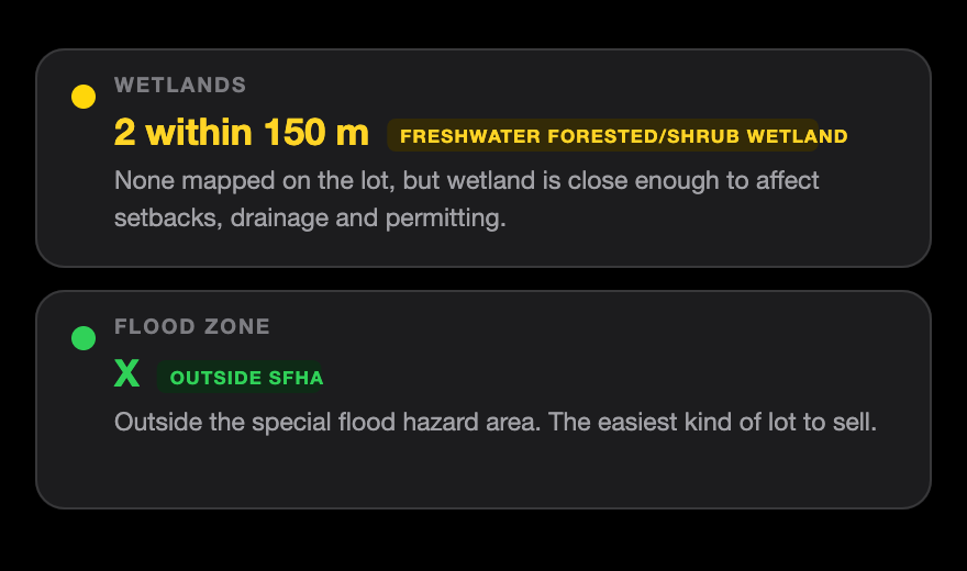
Mapped wetland on the parcel, and within 500 feet. Wetland next door still drives setbacks, drainage and permitting.
Straight from FEMA's National Flood Hazard Layer, with the base flood elevation where FEMA publishes one.
Whether water and sewer are mapped to the lot and who the franchise holder is, plus the zoning code and lot size.
Current owner and sale history from the county roll, including when one deed covered several parcels and the price was not for this lot alone.
Florida scrub jay from county layers where a county publishes one, and the USFWS consultation area where it does not.
Drainage class, depth to the water table and slope, from the USDA soil survey and USGS lidar. The reason lots get rejected late.
Said plainly, because a tool that is vague about its own coverage is a tool you cannot trust.
Everything above, plus the county record:
Live from the county where it publishes openly, and from the Florida Department of Revenue statewide roll everywhere else, labelled with its year so you know what you are reading.
Outside Florida the county half is not wired up yet. We say so in the app rather than showing you a blank and letting you assume. More Florida counties are being added every month, and more states are coming one county system at a time.
Type an address, paste a parcel number, or drop a pin. Vacant land usually has no address at all, so the pin is not a fallback, it is the normal way in.
Green, amber or red on each check, with a sentence saying what it means for building. Not a wall of raw data for you to interpret.
Send a clean card of the results to a buyer, or export the whole day to CSV and drop it in your spreadsheet.
We sampled 121 points across Lehigh Acres and ran every one through the same layers the app uses. This is what came back.
Measured 15 September 2026 from FEMA, USFWS, Lee County and the USDA soil survey. See the full Lehigh Acres breakdown.
We sampled 121 points on an even grid in each of these and ran every one through FEMA, the national wetlands inventory and the USDA soil survey. No two markets read the same.
See the Florida overview, or browse every market.
More Florida markets are being added every month, and more states
after that, one county system at a time.
Seven days free, no card asked for. After that it is $9.99 a month or $99.99 a year, and you can leave whenever you like.
We ask for no card to start. Seven days free, and
when they run out nothing is charged, because there is nothing on file. You
subscribe only if you want to carry on.
Still in beta, and we say so on purpose. Counties publish
differently and their servers go down; when one does, the app tells you rather
than showing a clean result. More counties and more states are being added
every month. If something looks wrong, email support@landinseconds.com and it
gets fixed, usually the same day.
No, and be careful with anything that says it does. Parcel lines come from county GIS and are approximate, routinely off by several feet. Use them to see where the lot roughly sits, never to site a building. A survey, a wetland delineation and a call to the county are still what settle it.
No. Only FEMA and your local floodplain administrator can determine a flood zone for a specific structure. We show you what FEMA's published map says about the point, which is how you decide whether to keep looking at the lot.
Not on its own. It tells you the five or six things that most often make a lot unbuildable, fast enough that you can check thirty lots in the time it used to take to check one.
Flood zone, wetlands, soil and elevation work anywhere in the United States. Owner, mailing address, value and sales history come from the Florida Department of Revenue parcel roll, which covers all 67 counties. Zoning and utilities are published by individual counties rather than the state, so those are live where we have wired up that county: zoning in Charlotte, Lee and Marion, utilities in Lee. We add counties one system at a time, because every one of them publishes differently. When a county has no layer, the app says so rather than showing you a blank and letting you assume.
Because most of them have none. Addresses get assigned when something is built. Search by parcel number, or drop a pin on the lot. Both work here, and that is the main reason tools built for houses cannot find raw land.
We say so, instead of showing you an empty card. County GIS servers go down regularly, usually overnight while they reload. A blank that looks like an answer is worse than no answer, so when a county goes quiet we fall back to the Florida state roll and label it with the year.
It varies by source and we tell you which one you are reading. County records are live where the county publishes them. The state roll is yearly. Wetland mapping is aerial interpretation that can be years old. FEMA updates as it revises maps. None of it is a substitute for calling the county.
Free while we are in beta. Create an account and start checking.
Get started